Sunday morning, we met our guides
(Fred and Dave from Black Sheep Adventures) at McCarran airport in Vegas and climbed
aboard the van and headed toward Death Valley.
About 3 hours out we stopped at the Amargosa Opera House for a brief
tour. This is a unique venue located at a
deserted T intersection in the middle of nowhere. The Opera House was created by Marta Becket
who Wikipedia describes as an
American actress, dancer, choreographer and painter. She developed the opera
house out of a deserted theater and performed there for more than four decades.
She passed away in 2017. We were
scheduled for an 11 am tour, and arrived a bit early on a cool, windy day. We found the tour guide in the motel office that
looked to be straight out of the Eagles’ song ‘Hotel California’. We shuffled around the little foyer/museum
until it was time for the tour. We were
quite surprised when, right at 11, three other groups of 2 or 3 folks showed up
for the tour. Evidently, Marta still has fans. Her life and the development of
the Opera House is the subject of the documentary film ‘Amargosa’.


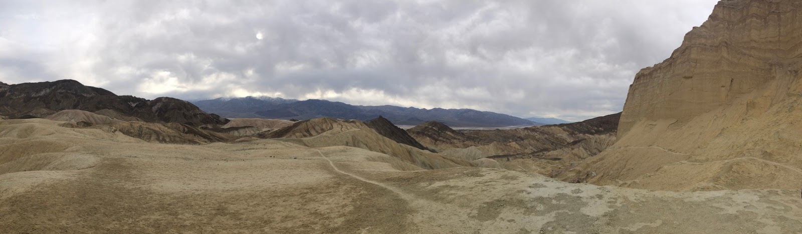
After the tour, we continued to Death
Valley and took a glorious hike in Golden Canyon, just south of Furnace Creek.
This was a 5-mile loop that took us over varied terrain.

And up to the base of Manly Beacon, an
iconic peak in the park.

Some of the sections of trail were easier than
others!

We were staying at the Furnace Creek
Ranch and before dinner Sally and Gail managed a delightful swim in the warm
spring-fed pool (no pics). It was Sunday night and the Academy awards were
happening. We missed the red carpet much
to the dismay of some in the group, but we did get to enjoy watching the two
Freds demolish a tomahawk steak.

The next day (Monday) was an amazing
and memorable day – albeit with a rough beginning for me. The first activity of the day was viewing the
sunrise at Zabriskie Point to watch the evolution of color on the desert
landscape. This meant getting up at 5:30
or so, then meeting at the van at 6am for a short drive to the lookout. In
anticipation of the early departure, I had laid out my clothes the night
before. Good thing, because I opened my
eyes at exactly 6:00. Oops! I somehow jumped into my clothes and
stumbled, bleary eyed, to the bus at 6:05, a couple minutes ahead of my roommate,
who’s alarm had failed. The others on
the trip were already in the van and chatting merrily, while I huddled in the
back, hoping for coffee to magically appear.
The colors at sunrise were
spectacular, and thankfully our guide Dave did have a thermos of coffee, so my
outlook was able to brighten along with the rising sun. We toasted the sunrise and headed back to the
lodge for breakfast.


After breakfast and a lot more coffee,
we headed to the Ubehebe Crater in the north section of the park. It is a bit
of a drive, and we took a brief rest-stop at a closed ranger station. Goldy and I spotted what looked to be an
exciting hike nearby. Fortunately, were pressed for time and had to move on.

The Ubehebe crater, besides being
quite scenic, is interesting geologically as it was formed by a steam explosion
600 ft below the surface. No molten lava – just hot rock and water. We took and windy, exhilarating and not too
treacherous hike around the rim.


After hiking the crater we were
shuttled a few miles back south, where we donned cycling clothes, hopped on our
bikes and had one of the best rides a cyclist could have – 32 miles on a long
straight downhill grade, with wind at our backs! I led out, and soon there was no one in my
mirror. I held my speed to 45 mph and
slowed every so often to maintain contact with the group. What a ride, fast and scenic on a smooth,
open and empty highway!


It seems that Gail was enjoying the ride!

After those miles of cycling bliss, we
arrived at the van, where Dave had put together quite a nice lunch for us. The dude makes a mean guacamole!

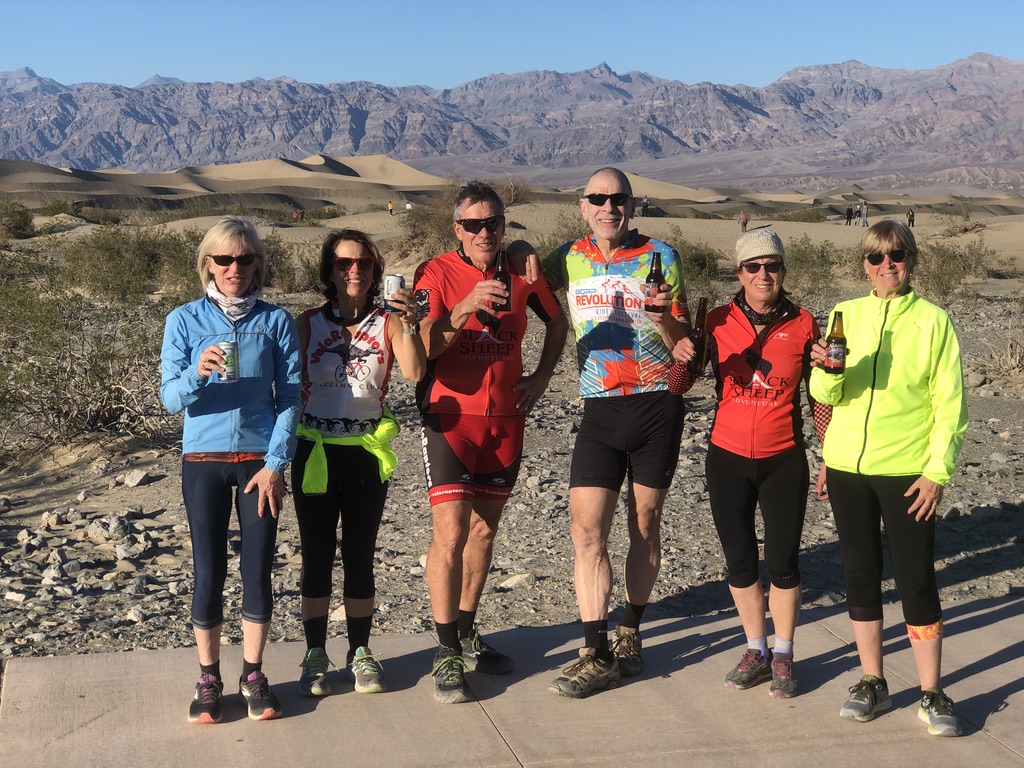
After lunch we rolled on down a gentler
slope to Stove Pipe Wells and the nearby sand dunes. While the more ambitious
of us walked around, the others found a great spot to relax with a libation,
enjoy the dunes and celebrate the day.


That evening Pauline lead a group to
the bar and they mostly ordered doubles!

The next day we spent a lot of time
riding. Some on a bike, but mostly in
the van. We started early and journeyed
high over Death Valley to Dante’s View which affords a fabulous view of
Badwater and much of the National Park. Despite
the name it was cold and windy.
Evidently, Dante came up here to cool off. Yes, that is snow on the Panamint Range
behind us.


After braving the wind and cold, we drove
down to Zabriskie Point, grabbed the bikes and pedaled the 20 miles (again
DOWNHILL!) to Badwater, the lowest point in the US. A few preparations before riding, smiling,
sunscreen, checking electronics…


Our stop at Badwater
– choreographed by Pauline (the video is worse)


All that action, and
it wasn’t quite noon. Our eventual
destination for the day was Pioneertown, near Yucca Valley, but we needed a
couple more adventures along the way. Our lunch stop was in Shoshone, a dusty
outpost that is easy to miss as you drive through (as I did after this past
Thanksgiving). But, oh what marvels await for those who stop. Actually, it is a very small, rustic old west
town that has a cool little museum that is worth a brief look and a
restaurant/bar with lots of local color. We didn’t venture too close to the old
jalopy in front of the museum because the ‘roof’ over the car is as shaky as it
looks. The museum has a collection of mammoth bone that were discovered
locally, a history of Jack Madison the local bootlegger, and other exhibits
showing aspects of local history.

After lunch we took a
detour to the China Ranch Date Farm and Bakery for a date milkshake (www.ChinaRanch.com).
Half the fun was getting there. On a map it looks innocous enough, take
Furnace Creek Rd to China Ranch Road and take that to it’s end - about a
mile. The first half mile or so is
non-descript high desert, but then the road descends steeply through an unpaved
narrow, twisting, canyon with high, unstable walls lined with interesting rock
formations.

I was thinking what a
great spot for an old west hideout. If
the ride down doesn’t take you back in time, then the tin lizzie at the bakery
will.

The milkshake was
fabulous, and once again we were amazed at the number of other tourists in the
place. We actually had to wait in
line! The bakery has several versions of
date bread and a plethora of knickknacks.
We bought date cookies (yum) for the drive, and date bread to take home.
Moreover, as I was arriving home late on Valentine’s Day, it was fortunate that
they also had greeting cards appropriate for that occasion.
Dinner that night in
Yucca Valley was interesting in that while the menu in the restaurant was fairly
extensive, it was best to order either the burger or mac and cheese, as these
were the only options available – it was off season in the desert. The restaurant
also had a picture on the wall of a mushroom cloud taken on the Tonopah test
range. Being retired from a Gov’t
defense lab, I tend to notice these things.
Breakfast at the Natural Sisters Café
was vegan and very good. I had the
sliders with vegan sausage. After breakfast we headed out on bikes for a 64-mile
ride through Joshua Tree National Park and then on to Mecca at the north end of
the Salton Sea. Chris and I took a break
at the entrance.

And in case you
are wondering, this is a Joshua Tree.

The park has just fabulous rock
formations and wonderful areas of Cholla and another cactusus. We pedaled
along, stopping often to read the information plaques along the road. I was surprised to learn that In more verdant
times (10,000 yrs. ago) one of the Southwest's earliest inhabitants, Pinto Man,
lived here, hunting and gathering along a slow moving river that ran through
the now dry Pinto Basin.
Read more: https://www.desertusa.com/jtree/jtdes.html#ixzz6HSoCPeXN
Read more: https://www.desertusa.com/jtree/jtdes.html#ixzz6HSoCPeXN
Moreover, Joshua Tree is
where the Mojave and Sonora deserts meet.
Thus, it is home to many species that are characteristic of each desert
region including big horn sheep, greater road runner and the desert tortoise
(note, while working in Nevada I was trained in handling desert tortoise, so no
worries if we encountered on the road, I could move it safely!)


Rounding a curve and heading down a
gentle grade we were overlooking this amazing field of Cholla cactus and had to
stop. Across the road this ocotillo was
calling Goldy’s name as well.


The twenty miles from Joshua Tree to
Mecca was also great for biking. We had a smooth cruise over good pavement, no
traffic and the road was either level or gently sloping down, through a broad
canyon. The
van picked us up in Mecca and as the February days were short, we arrived in
Borrego Springs after dark.
Our
last full day was in Borrego Springs and it was a bit fantastical. That’s
because there is more than desert wildflowers and the beautiful landscapes in
this part of the desert. The area is
home to 130 amazing full-sized metal sculptures that are inspired by creatures
that roamed this same desert millions of years ago. The artworks range from
prehistoric mammals to historical characters, fanciful dinosaurs, and large
serpent. After a fine breakfast (more on
that below) we headed out on bikes and Chris and
Robin managed to find the serpent. Note, this sculpture is 350 ft long! While we were there a fellow with a drone took
a nice aerial shot. Check this website for a look at the sculptures


Speaking of flying objects, while wandering amongst the creatures we
also encountered a group paramotor flyers that had buzzed in from El Centro. A
paramotor is essentially a paraglider, then you strap a motorized propeller on
your back and takeoff. It took them
about an hour of flight time to reach Borrego Springs. Follow this link to see
a demo https://www.youtube.com/watch?v=rS9ookJt8bM
After
carousing with the monsters, droners and paramotors, we encountered the biggest
challenge of the trip, a ride up the Glass Elevator – Montezuma Road – 10 miles
of 8-11% grade, with a bit of 14% at the start to get us going. The climb was
long, some might say epic with amazing views throughout the relentless
climb. It is in some ways comparable to
Mt Diablo, but without the easy bits, and with high speed traffic and a few large
trucks. The shoulder is wide in most spots, so it wasn’t
too frightening.

Our guidance was to stop at the Yeti, a way beyond the crest. He (the Yeti) wasn’t too hard to find, and once there enjoyed what Sally called some ‘mundane but utterly delicious ice cream’. After a rest at the Yeti, we had the pleasure of the descent back into Borrego Springs and a stop at the taco stand for lunch.


Then it was back to the resort where
Goldy and I enjoyed a soak in the hot tub while others went off to explore a
slot canyon.
Because this is also a bakery blog I
must mention the delicious croissant breakfast at the Casa Del Zorro. Their croissants were light but with a slightly
crisp flaky crust, not too big, but not small.
Croissant were served with fresh fruit, butter and jam. Put that with a side of bacon that was again prepared
just right – and a cappuccino. I highly
recommend it. I had it both mornings.
The Casa Del Zorro, besides being a
classy place is memorable in other ways as well. One of them being the
omnipresent foxes. They are featured on the bar-room walls and on the guest
room beds. They are available for
purchase with the proceeds going to a local charity. I managed to resist!


Thanks to Sally for putting this trip
together


And to our guides Fred and Dave for
making it amazing.

